Global agricultural lands in 2015
As a follow-up to Farming the Planet: 1. Geographic Distribution of Global Agricultural Lands in the Year 2000, we have been creating global maps of pasture and cropland for the year 2015. This work consists of searching databases and government websites for census data on agricultural area, helping build a machine learning model to predict cropland and pasture area from MODIS land cover classifications, and evaluating the outputs against existing products. See ramankuttylab.com/data for more information/the final product when it becomes available.
Publication in prep (Oct 2023). |

|
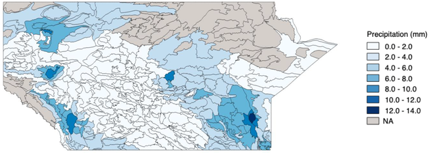
Climate-smart agriculture in the Canadian Prairies
I am helping manage, clean and wrangle data for a project funded by Alberta Innovates on climate-smart agriculture in Canada. This has involved spatial analysis and dealing with large time-series datasets. For example, I have computed cropland-area weighted means of climate variables and harmonized management variables from Statistics Canada. Through this project, I learned to leverage high performance computing resources and parallelization.
|
|
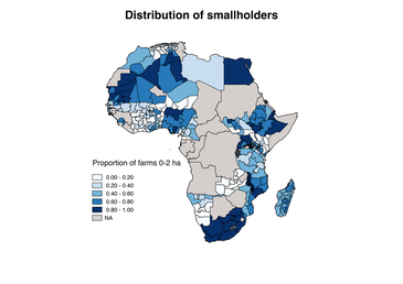
Distribution of smallholder farmers in Africa
The Smallholder Adaptation Atlas is a project led by the Gates Foundation aiming to help high-level decision makers better understand adaptation challenges/options/solutions. A layer of where smallholders are is a fundamental base layer. I helped create this base layer by pulling together subnational data from various sources and harmonizing it to consistent farm size classes and attributes.
|
|
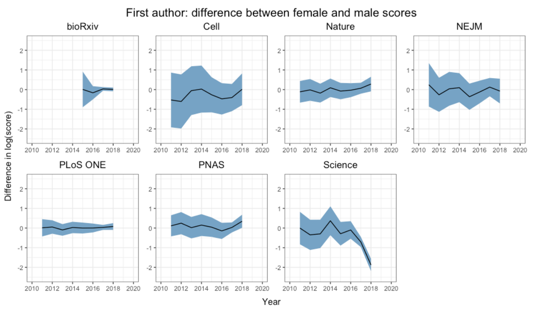
Altmetrics and gender bias in academia
The Altmetric Attention Score quantifies how much attention a scholarly article receives outside of traditional academic circles, e.g. by counting mentions on Twitter, in the news, etc. Given the large body of literature surrounding gender biases pervasive in metrics used to evaluate academics, we wanted to see whether these biases were also present in Altmetrics. We used linear and logistic models to test for differences in altmetric scores between female and male first and last authors. We found that there is generally no difference, except in 2017 and 2018 in the journal Science, for reasons were were not able to identify in this study.
|
|
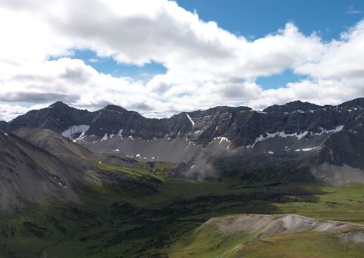
Landscapes in Motion
I was involved with the Landscapes in Motion project as part of the Oblique Photo Team. The project's broad objective is to improve our understanding of historical wildfire regime in southwestern Alberta in order to better manage forests based on the principles of ecosystem-based management.
My work with the Oblique Photo team involved developing a custom software tool to georectify the Mountain Legacy Project's photographs. By extracting spatial information from historical oblique photographs, we can gain information on the state of the landscape decades earlier than possible through satellite imagery. |
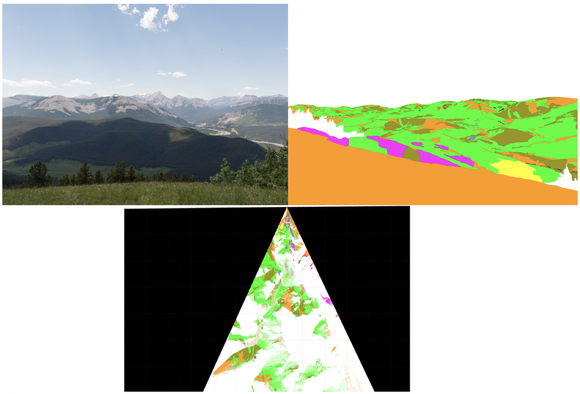
The tool takes as input camera parameters & a Digital Elevation Model and creates a virtual photograph and a viewshed. This can then be used with classified oblique images to approximate area coverage of different classes from the photograph.
|
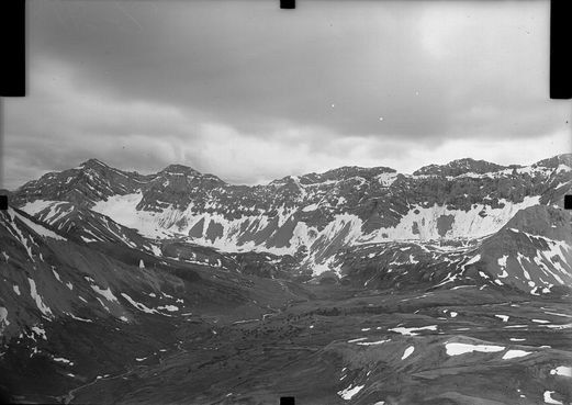
Mountain Legacy Project
My Master's thesis was part of the Mountain Legacy Project, supervised by Dr. Eric Higgs.
The Mountain Legacy Project is based on historical photographs taken by surveyors in the late 1800s to mid 1900s that were used to create topographic maps of western Canada. My research involved going back to the same locations and retaking the exact same photographs, then comparing image pairs to analyze century-long change. I studied this in the Willmore Wilderness Park in Alberta; the park is highly protected from direct human disturbance, which makes it an ideal area to study land cover change resulting from indirect change. I found that the landscape has become more homogeneous in recent years; there is more coniferous forest now than in the past. I further found that this affected the avian community of the park: as available habitat has shifted, species distributions have shifted in favour of coniferous forest-adapted species. One manuscript on this work has been published in Remote Sensing in Ecology and Conservation. An additional manuscript is under review (Oct 2023).
|
|
Bayesian Updating of Land Cover
Are you familiar with Google Earth Engine's Timelapse feature? (If not, you should definitely check it out)
For my undergraduate Honours thesis (supervised by Dr. Jeffrey Cardille), I helped develop an algorithm that would create a timelapse similar to the Google Earth Engine timelapse feature, but of classifications of satellite imagery rather than of the satellite images themselves. The algorithm applied Bayesian statistics to "learn" about changes in land cover and would output classified maps of better quality than those with which it was fed. Check out this publication for more detailed info on how the algorithm works, demonstrated on a forest fire in northern Quebec.
And this publication for a case study tracking deforestation in the Brazilian Amazon. |
An example of the BULC algorithm tracking deforestation
around the Roosevelt River in Mato Grosso, Brazil
|
Grizzly bear movement through circuit theory
One way of measuring habitat connectivity is to imagine the landscape as a circuit in which each land cover type (e.g. forest, grassland, water) has a different resistance. If you were a grizzly bear that liked walking through open meadows but didn't much enjoy bushwhacking through dense forests, you might assign a low resistance to grassland and a high resistance to forest. This is the idea behind Circuitscape, a program that estimates habitat connectivity based on electronic circuit theory. I applied Circuitscape with grizzly bear telemetry data to see how circuit theory helped predict bear movement.
|
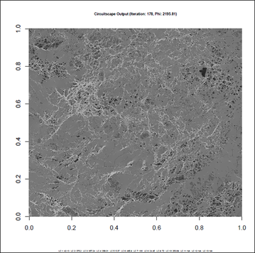
An example of a square section of landscape coloured according to resistance values, illustrating potential animal movement corridors
|
